Skip to content

Cottonwood Heights

Cottonwood Heights drainage is a snowmelt problem

A rainstorm is over in an hour. The melt runs for six weeks, day and night, into ground that is already full. Those are different problems, and only one of them is what most yards here are built for.

Published August 24, 2026

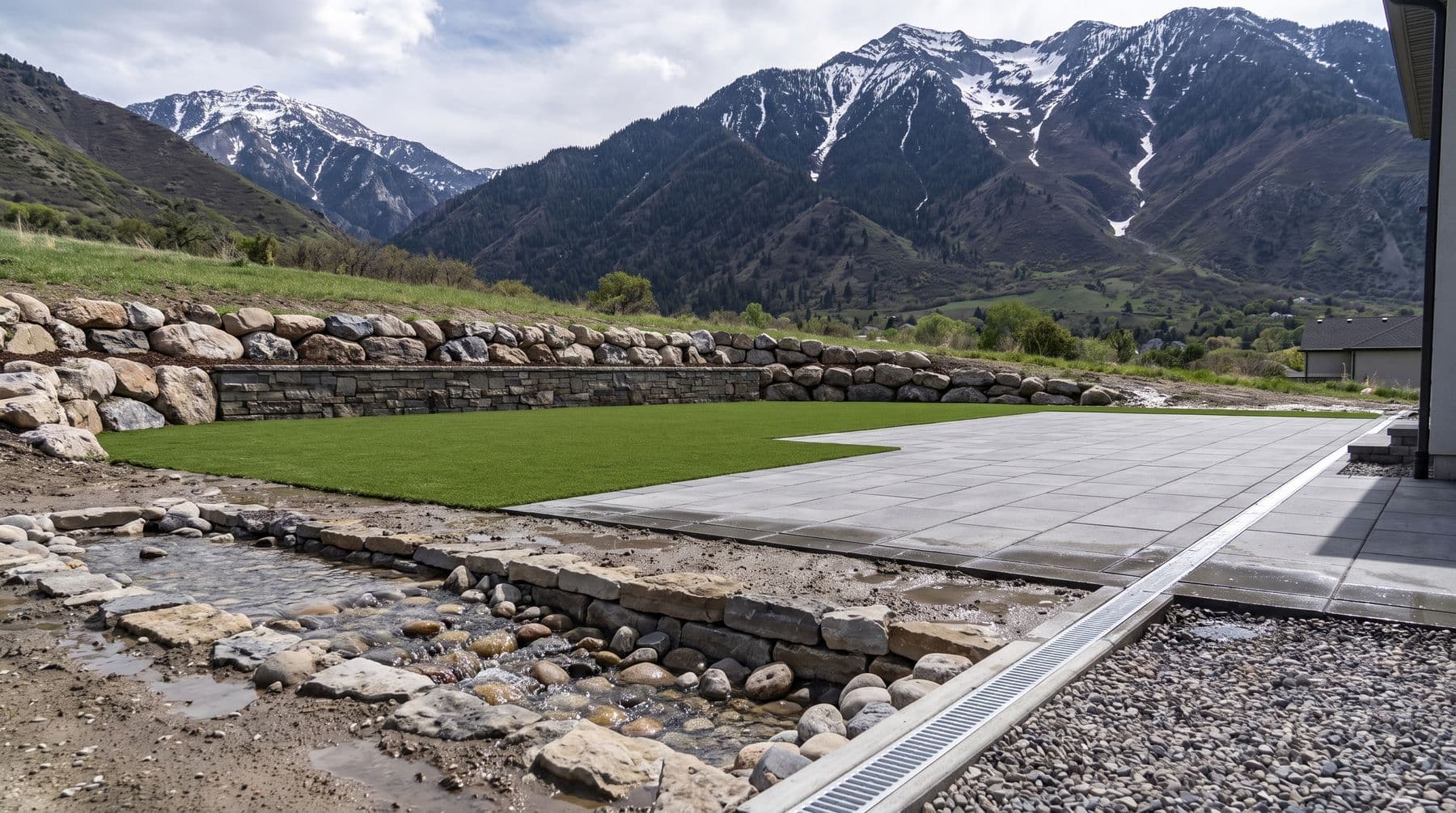
A backyard on the bench below a Wasatch canyon mouth in late spring, turf lawn and paver terrace above a stone-lined swale carrying snowmelt, snow still streaking the peaks behind

The short version

Of the 86 annual peak flows recorded by the USGS on Big Cottonwood Creek at the canyon mouth between 1901 and 1989, 48 came in May and 37 in June — 85 of 86 in two months. On Little Cottonwood Creek, all 57 peaks on record fell in May, June or July. The design event in Cottonwood Heights is therefore not a depth but a duration: the median peak snowpack at Brighton, near the head of the canyon, is 24.1 inches of water, against a 100-year 24-hour rainstorm of about 3.42 inches at the canyon mouth. A yard that drains a shower fine can still fail in April, because the melt arrives for weeks into subgrade that is already saturated. Drainage here has to convey water to a legal outlet, not soak it away.

Eighty-five of the last eighty-six floods came in May or June

The USGS ran a stream gauge on Big Cottonwood Creek at the canyon mouth — station 10168500, draining 50 square miles of the Wasatch directly above this city — and recorded an annual peak flow in 86 separate years between 1901 and 1989. Forty-eight of those peaks fell in May. Thirty-seven fell in June. One did not, on 27 September 1982, and it is also the largest figure in the record.

The gauge on Little Cottonwood Creek (station 10167500, 27.4 square miles) tells the same story with even less ambiguity: 57 annual peaks between 1912 and 1980, of which 24 came in May, 32 in June and one in July. Not a single annual peak on that record falls outside the melt season.

Both gauges stopped reporting decades ago, so this is a historical record rather than a live one, and we are not going to pretend otherwise. But it is the longest continuous statement anyone has about how water behaves at these two canyon mouths, and what it says is unambiguous. The flood that reaches a Cottonwood Heights backyard is a melt flood.

The other half of the record matters more than the peak. Across the 30 complete water years of daily flow from 1960 to 1989, Big Cottonwood Creek ran at or above 200 cubic feet per second on a median of 40 days a year, and April through July carried a median 69 per cent of the entire year's flow volume. That is the shape of the problem. Not a spike. A season.

The mountain holds more water than any storm will deliver

The NRCS snow telemetry site at Brighton sits at 8,790 feet near the head of Big Cottonwood Canyon and has measured snow water equivalent since 1986. Across 39 complete water years from 1987 to 2025, the median peak snowpack there held 24.1 inches of water. The thinnest year on record held 13.3 inches. In 2023 it held 42.5.

Now the comparison. NOAA Atlas 14, queried at the Big Cottonwood canyon mouth, puts the 10-year 24-hour rainfall at 2.41 inches and the 100-year 24-hour rainfall at 3.42 inches. The heaviest single hour a century is expected to produce there is 1.95 inches. Cottonwood Heights sizes its own on-site retention requirement for new development against the 80th percentile rainfall event, which the city states as 0.58 inches.

So the snow at the top of the canyon routinely holds something like seven times what a hundred-year rainstorm would drop, and it lets go of it over about six weeks rather than a day. The city's storm drain code is honest about this in its definitions: section 17.04.020 defines storm waters as flow resulting from precipitation or snowmelt runoff, and the sensitive lands chapter lists snow melt and storm water runoff among the natural hazards it exists to protect people from.

None of which means a rainstorm cannot hurt you. September 1982 is right there in the record. It means that if you only design for the rainstorm, you have designed for the smaller and shorter of the two events your yard has to survive.

Why duration breaks the usual drainage answer

The standard fix for a wet yard is to make water go into the ground: a dry well, a soak-away, an open-graded base under the turf, a gravel bed under a patio. Every one of those depends on the subgrade beneath it accepting water at some rate. In July, on the alluvial ground at these canyon mouths, most of them test beautifully.

In April the subgrade is already full. It has been taking meltwater for weeks, the water table under the bench rises with the creek, and the ground at the start of the melt is often still frozen at depth. An infiltration device with saturated soil underneath it is not a drain. It is a bucket, and a bucket fills.

The city writes this into its own rules in the least likely place. Section 17.08.020 sets out what a soils report has to contain before the public works director will permit improvements over a high water table, and one requirement is that the report contain an examination of the water table during the period from April through June. The city does not accept a summer reading. Neither should you, and neither should whoever quotes your yard.

There is a genuine consolation in the ground itself. The alluvial fans at the canyon mouths are full of rounded cobble and gravel, which is expensive to dig and slow to haul, and which also drains far better than the clay most of Utah County builds on. Where you hit it, it is an asset. It is not, on its own, a plan.

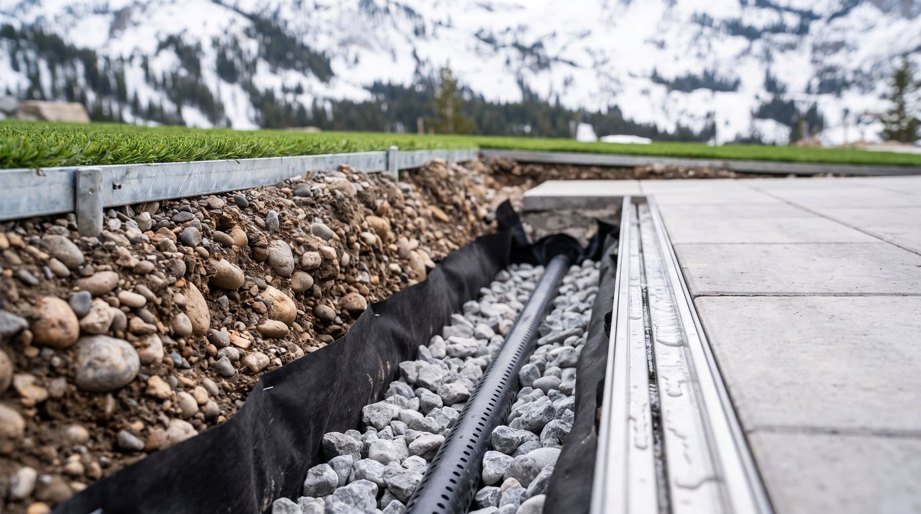
A fabric-lined drainage trench filled with washed rock around a perforated pipe beside a paver edge channel drain, the cut face showing rounded alluvial cobble through the soil

What changes about how the yard gets built

None of this makes a good backyard impossible here. It changes the order the design gets drawn in, and it moves a few line items out of the optimistic column.

  • Find the flow path before anything else. Water crossing your lot in May already has a route. The first drawing is where it enters, where it crosses and where it leaves — not where the patio goes.
  • Intercept above the yard, not below it. A drain at the low corner is catching water that has already run through everything you paid for. A cut-off drain or swale at the uphill edge stops it before it gets there, and it is usually the cheaper of the two.
  • Size the outlet, not the trench. A gravel trench holds a fixed volume and then it is full. Over six weeks the only number that matters is what leaves the far end, continuously, to somewhere legal.
  • Draw the overflow route on purpose. Ask where water goes when the system is at capacity, because for several weeks a year it will be. If the honest answer is against the house, the design is not finished.
  • Grade away from the structure first. Section 17.08.020 requires that all grading of any kind be done so drainage runs away from the improvements and does not convey or trap water against basement and foundation walls. That is the one rule with no exceptions and no cheap fix.
  • Do not treat turf as drainage. Turf backing perforates and drains quickly, and turf is not an impervious surface — but the base and the subgrade underneath decide everything, and a turf lawn laid across a spring flow path is simply a flow path you can no longer see.
  • Do not turf the flow path at all. Where water genuinely runs, a rock-lined swale is the right surface. At $4 to $9 a square foot for decorative rock against $13 to $19 for turf, that is one of the rare occasions where the correct answer is also the cheap one.
  • Keep the drain line and the discharge point on the quote as their own lines. A regrade is inside a normal install. A drain run, a catch basin and a legal outfall are not, and any quote that leaves them implied has left them out.

The rules that actually bind a homeowner

Most of Cottonwood Heights municipal code title 17 is aimed at developers, and most of the permit thresholds — a SWPPP over one acre of disturbance, a fugitive dust permit over a quarter-acre — are well above a backyard. Four things in it reach an ordinary homeowner, and all four are worth knowing before a crew is booked.

  • The extra water is legally yours. Section 17.04.020 defines excess waters as those created by altering the terrain or increasing the impervious surface of the property, over and above what the unaltered ground would have shed. Section 17.04.040 makes it the property owner's responsibility to control and contain those waters or discharge them into a drainage system facility, and to build and maintain private drainage facilities at the owner's expense. Solving your yard by moving water onto the neighbour's is not a solution the code recognises.
  • High groundwater needs written permission. Section 17.08.010 makes it unlawful to make any improvements where subsurface water exists within two feet of the foundation level of those improvements without the written permission of the public works director — and it names homeowners constructing improvements upon their own property explicitly, not just subdividers and developers.
  • There is a list of what you may lawfully put into the storm drain. Section 17.18.070 prohibits discharging anything but storm water, then exempts, among others, foundation and footing drains not connected to floor drains, crawl space sump pumps, rising ground water, ground water infiltration and landscape irrigation. So a properly built French drain or sump outfall is a permitted discharge. Silt-laden yard water off a live excavation is not.
  • The material pile in front of your house is regulated. Section 17.18.060 prohibits stockpiling topsoil, fill, sand, gravel, landscape rock, bark or mulch in the street or gutter unless it is in a self-contained unit pre-approved by the department or expressly allowed in an approved SWPPP, and it makes the owner and the contractor jointly and severally liable for mud tracked onto the road. Enforcement runs from a stop work order up to a class B misdemeanour for an intentional or reckless violation, each day a separate offence, and the city may install controls itself and bill the owner and contractor for the cost plus a 25 per cent penalty.

The standard the city holds everyone else to

You will not be asked to engineer a backyard to municipal standard. It is still the most useful yardstick available, because it is the city stating in writing what it thinks this ground requires.

Cottonwood Heights maintains 89 miles of storm drain pipe and channel between 4 and 84 inches, 1,620 structures and 104 outfalls into Big Cottonwood Creek, Little Cottonwood Creek and the East Jordan Canal. Section 17.04.020 designs the intermediate parts of that system to a ten-year frequency flood. Where a development has to detain water, section 17.04.070 — amended by ordinance 395 in April 2023 — caps the release rate at 0.2 cubic feet per second per developed acre, and at 0.1 inside a sensitive lands overlay zone.

The sensitive lands chapter, 19.72, is stricter still, and by its own terms applies to all lands located in the city. Stormwater facilities must be built first, before anything else on the site, and must detain the 100-year storm while discharging no more than 0.1 cubic feet per second per acre. Existing natural drainage channels have to remain where they historically are. Where a channel is needed, the code asks for wide shallow swales lined with vegetation or rock instead of narrow deep ditches. Impervious coverage is capped at 30 per cent of any part of a project where a slope stability hazard is present, and beyond that on-site retention is required.

The same chapter is where the wall limits live, and they are tighter than Draper's. No development at all — including grading, retaining walls and structures — on slopes over 30 per cent, save for a narrow exception; and where that exception applies, a slope retaining structure is capped at four feet, with terraced walls limited to twelve feet combined. If your lot climbs hard toward the canyon, that is the number that shapes the design.

All of it is paid for by a monthly stormwater fee, set at $8.69 per equivalent residential unit for 2026-27 on the city's fee schedule and rising three per cent a year. One ERU is 4,000 square feet of impervious surface, which the city defines to include concrete, patios, sports courts, parking lots and rooftops. Whether a specific patio changes a specific bill is a question for the city's stormwater fee policy manual and its fee waiver process, not for us — but it is worth asking before you add a large one, and worth knowing that a grading permit here is charged at 100 per cent of the IBC schedule.
What we would actually do with the yard

Zone it. Turf where the family actually stands, hardscape where the furniture goes, and rock and drought planting across whatever the water uses in May. On a canyon-mouth lot the flow path is not a defect to be paved over; it is the cheapest square footage on the quote and the part that will still look deliberate in year five.

Terrace only as much as you need. Wall face runs $55 to $110 a square foot and paver patio $26 to $40, against $4 to $9 for decorative rock. The slope you leave as slope, planted and boulder-set, is both the cheap answer and the one that lets water do what it was going to do anyway. We do not take jobs under about $5,000, because mobilisation, demo and haul-off are largely fixed and swallow a small budget.

Then be clear about what landscaping cannot do. Nothing we build stops a creek. If your property backs Big or Little Cottonwood Creek or Deaf Smith Creek, the city asks you to monitor and clear debris from the streambed before levels rise and to pile it at the kerb for Public Works to collect on 801-944-7002; Salt Lake County issues residents 25 sandbags a day; and overland flooding or channel erosion goes to county flood control on 385-468-6600. A drainage plan for a backyard is a plan for the water crossing your lot, not for the creek at the bottom of it.

The reason to get this right is not the flood. It is that base built over ground which saturates every April moves, and moving base is what turns a flat lawn into a wavy one and a level terrace into a settled one, three or four seasons after the crew has gone. Drainage is the part of this job that decides whether the rest of it survives.

Common questions

When does spring runoff cause problems in Cottonwood Heights?

May and June, overwhelmingly. Of the 86 annual peak flows the USGS recorded on Big Cottonwood Creek at the canyon mouth between 1901 and 1989, 48 came in May and 37 in June; on Little Cottonwood Creek every one of the 57 peaks on record fell in May, June or July. The bigger point is duration rather than date: across 30 complete years of daily record, Big Cottonwood Creek ran at or above 200 cubic feet per second on a median of 40 days a year, and April through July carried a median 69 per cent of the whole year's flow.

Do I need a permit to fix drainage in my Cottonwood Heights backyard?

Often not for the landscaping itself — the storm water permit thresholds sit at one acre of disturbance for a SWPPP and a quarter-acre for a fugitive dust permit, both above a normal backyard. Two things can still catch you. A grading permit is charged at 100 per cent of the IBC schedule, so ask community development where your excavation lands. And under section 17.08.010 it is unlawful to make any improvements where subsurface water sits within two feet of the foundation level of those improvements without the written permission of the public works director, a requirement the code applies to homeowners on their own property by name.

Will artificial turf help or hurt drainage on a canyon-mouth lot?

Neither, on its own. Turf backing is perforated and sheds water quickly, and turf is not an impervious surface, so it does not add runoff the way a slab does. But the base and the subgrade underneath decide what actually happens, and turf laid across a spring flow path is a flow path you can no longer see. Where water genuinely runs in May, a rock-lined swale is the right surface — $4 to $9 a square foot against $13 to $19 for turf — and the turf starts outside it.

Can I drain my yard into the street, the storm drain, or onto my neighbour's lot?

Onto the neighbour, no. Section 17.04.020 defines the extra water your improvements create as excess waters, and 17.04.040 makes controlling and containing it the property owner's responsibility, at the owner's expense. Into the storm drain, some things yes: section 17.18.070 permits foundation and footing drains not connected to floor drains, crawl space sump pumps, rising ground water, ground water infiltration and landscape irrigation, while prohibiting everything else. Silt-laden water off an open excavation is not on that list, and neither is a pile of base rock left in the gutter — 17.18.060 prohibits that too, and makes the owner and the contractor jointly liable.

Next step© 2026

Get a free yard estimate*

Send your address and a couple of photos. We come measure, and you get a written number with base depth and materials spelled out.

Get my free estimate